Sayre Loop Pilot Project

The Sayre Loop Pilot Project is scheduled for April 7-14, 2024 and will impact travel on Upper and Lower Sayre Park Roads.

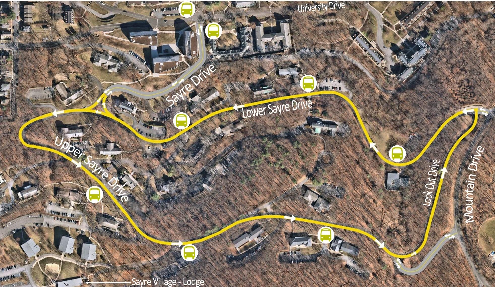
In an effort to improve connectivity between Lehigh campuses and increase motorist, pedestrian, and bicyclist safety on Upper and Lower Sayre Park Roads, Lehigh University is undergoing a pilot project that will alter the traffic pattern on these roads from April 7 to April 14, 2024.

This project will gather data that informs the best methods for increasing the safety of all who travel on these roads. Data collected during this project will be used to explore future safety initiatives for this area. This project furthers the university’s commitment to providing improved, safer access to Mountaintop and Goodman campuses from Asa Packer Campus.

The project will span the entirety of Upper and Lower Sayre Park Roads. During the April 7-14 timeframe, both roads will become one-way only, with vehicular traffic moving in a counterclockwise direction. One lane will be reserved for automobile traffic, and the other lane will be converted into a shared path for pedestrians and bicyclists. Regular traffic patterns will resume on April 15, 2024.

Sayre Loop traffic route

FAQs

During the pilot program, Upper and Lower Sayre Park Roads will become one-way only, with vehicular traffic moving in a counterclockwise direction. One lane will be reserved for automobile traffic, and the other lane will be converted into a shared path for pedestrians and bicyclists.

This project furthers the university’s commitment to enhancing connectivity among campuses and providing safer access to Mountaintop and Goodman campuses from Asa Packer Campus. Under Lehigh’s strategic plan, Inspiring the Future Makers, this serves as the first step in improving connectivity between campuses. Additionally, the university is exploring ways to increase safety for all who travel Upper and Lower Sayre Park Roads by car, by bicycle, and on foot. 

The pilot project is informed by the traffic data collected through automated speed monitoring, as well as feedback collected through the Lehigh University Master Plan and Parking and Planning Study processes. Data indicates that a high number of cars travel Upper and Lower Sayre Roads exceeding the current speed limit, contributing to crashes and safety concerns among pedestrians and bicyclists. 

The university has been working closely with the City of Bethlehem, as well as Lehigh and Bethlehem Police, Fire and Emergency Medical Services (EMS) to ensure a seamless transition to this new traffic pattern. All are aware of the change in traffic flow in the area and have developed plans to ensure that all residences and buildings along Upper and Lower Sayre Park Roads are accessible in an efficient and timely manner. 

Detour signs will be posted to notify motorists of the path of travel. Signage and traffic control devices will be placed throughout the route to guide motorists.

The posted speed limit of 15 mph will remain in effect during the pilot program.

Additional enhancements being evaluated during the study include lighting, pedestrian connections/accessibility, bus stop improvements, and geometric roadway improvements. Additional feedback regarding potential safety and connectivity enhancements may be submitted via an upcoming survey. 

Yes, a mixture of traffic control devices will be installed throughout the pilot area to provide a buffer between pedestrians/bicyclists and vehicles. 

Community members are encouraged to familiarize themselves with the new traffic pattern in advance of the pilot and plan accordingly. Everyone is encouraged to consider walking or traveling by bus through the project area to provide the most applicable feedback possible. 

Community members are encouraged to utlize this route so that accurate data can be gathered during the pilot project. Community members are encouraged to consider walking or traveling by bus through the area to provide the most applicable feedback possible. 

We invite all community members to share feedback here. Additionally, there will be stations set up along Upper and Lower Sayre Park Roads during the pilot program where travelers can share feedback and thoughts on their experience traveling these roads.

A community meeting is scheduled for March 6, 2024, at 4:15 pm in the Sayre Park D Lodge. Residents are invited to hear more about the project,  ask questions, share feedback, and enjoy light refreshments.

This pilot project will allow the university to gather vital traffic data and community feedback in order to more effectively consider future plans for the area. 

After the pilot project is completed, data collected will be analyzed, in conjunction with community feedback, to explore next steps and future connectivity and safety initiatives for this area.  The overarching goal is the development of new ways for individuals to move across campus and between campuses in a variety of ways, safely.